UC 4: Slow-moving vehicle warning
Operation Use case
This use case is an addition on the 'slow moving service vehicle' use case. There will be an alert message if a vehicle is noticed to drive significantly slower than other traffic (see following paragraph for details) and therefore is creating a potential dangerous situation. Much effort is done to prevent alerts in this use case where is is a normal traffic jam.
Since this Mobilidata use case solely depends on information generation by connected service providers it is unclear if this will be an active use case after 31/12/2024.
Messaging
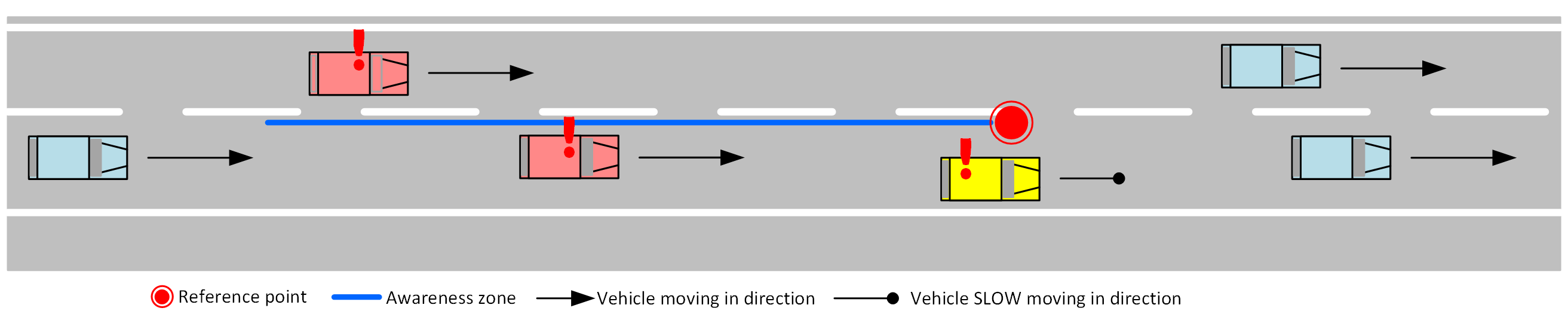
- The slow moving vehicle (yellow vehicle in above figure) will provide the message that it is slow moving. The link between message and vehicle is based on position (roughly the same as the reference point) and the speed.
- Other traffic will be warned when entering the awareness zone in the message (red vehicles in above figure).
Conditions:
- A vehicle is detected as 'slow moving' when it is actually driving below 58% of the allowed maximum speed on that particular piece of road. (= 70 km/h on a 120 km/h road section)
- Detection only active on highways with min. 30 consecutive seconds under the low-speed threshold of 70 km/h, but faster than 5km/h (classified as cut-of speed towards non-moving vehicles)
- No message is generated if the vehicle is in a known roadworks zone.
- no message is generated if the vehicle is in or nearby a known traffic jam.
Slow driving Alerts to the other road users:
- Slowing moving vehicle ahead warning issued, based on regularly updated DENM messages at least 1 updated position per 3 seconds.
- No RUF channel is provided, Real time automatically generated positions are supposed to be more accurate and faster than RUF.
Operational Road Environment
- Territory: Flanders
- Border passing cases: Covered by the II (improved interface) international C-ROADS workings.
- Road class: Highway (120km/h sections)
- Time restrictions: none
- Weather restrictions: none
- Special restrictions: none
Data sources
- C-ITS service providers connected to end user applications with low-speed functionality: currently only Flitsmeister in Proof Of Concept setting.
RUF and sourcing
Not applicable.
MI & Historical archive
DENM information
The DENM messages, generated for this use case, only have awareness traces and no history trace. This, because the characteristics of the slow moving vehicle are unknown, apart from the travelling speed.
The max validity life-span is 3 seconds in this use case
Cause and sub cause codes are:
| Causecode | Description | Subcausecode | Description |
|---|---|---|---|
| 26 | Slow Vehicle | 0 | unavailable |
MI Headers
Capability descriptor:
{
  "messageType": "DENM",
  "originatingCountry": "BE",
  "protocolVersion": "DENM:1.3.1",
  "publisherId": "BE00004",
  "publicationId": "BE00004:DENM_SLOW_MOVING_VEHICLE_01",
  "custom-mobilidata-publisherType": "PIP",
  "custom-mobilidata-dtapEnvironment": "production",
  "custom-mobilidata-useCase": [4],
  "quadTree": []
}
Historical archive
The DENM messages from this usecase are stored in the historical archive. No privacy issues.
Risk and remarks
Alert cancelling
N/A
Message example
UC 4 Message Example
- AMQP Header
- ASN.1
- JSON
{
  "shardId": "1",
  "latitude": "50.8998253",
  "quadTree": ",120202132203001122,1202021322030,",
  "causeCode": "26",
  "longitude": "4.3235312",
  "shardCount": "1",
  "messageType": "DENM",
  "publisherId": "BE00004",
  "subCauseCode": "0",
  "publicationId": "BE00004:DENM_SLOW_MOVING_VEHICLE_02",
  "baselineVersion": "2.1.0",
  "protocolVersion": "DENM:1.3.1",
  "originatingCountry": "BE",
  "custom-mobilidata-useCase": ",4,",
  "custom-mobilidata-timestamp": "1738135035680",
  "custom-mobilidata-alertCCodes": "1754",
  "custom-mobilidata-vehicleType": "generic",
  "custom-mobilidata-publisherType": "PIP",
  "custom-mobilidata-baselineVersion": "1.0.0",
  "custom-mobilidata-dtapEnvironment": "production"
}
010100000001c100000000b565135c46275404d71189d5053fb9b6d6ddd89f0ffffffe11dbba1f000480001a002870fc4b40dcb0503e39c418e906b7639c418eb06ade39c418e906ad639c41bb907ed639c41bcf07f2e39c41bb907ed639c41b69081f639c41b2f083de39c41b2f083de39c41a3d08b0e39c310372c140f8e71063a41add8e71063ac1ab78e71063a41ab58e710649417818e7106444176f8e710649c17838e710653416e38e710658416cd8e7106a8c1d998e71066741fdf8e710653420918e700
{
  "Header": {
    "ProtocolVersion": 1,
    "MessageID": 1,
    "StationID": 1
  },
  "Denm": {
    "Management": {
      "ActionID": {
        "OriginatingStationID": 1,
        "SequenceNumber": 27338
      },
      "DetectionTime": 665219840672,
      "ReferenceTime": 665219840672,
      "Termination": null,
      "EventPosition": {
        "Latitude": 508998253,
        "Longitude": 43235312,
        "PositionConfidenceEllipse": {
          "SemiMajorConfidence": 4095,
          "SemiMajorOrientation": 3601,
          "SemiMinorConfidence": 4095
        },
        "Altitude": {
          "AltitudeValue": 800001,
          "AltitudeConfidence": 15
        }
      },
      "RelevanceDistance": null,
      "RelevanceTrafficDirection": null,
      "ValidityDuration": 9,
      "TransmissionInterval": 1,
      "StationType": 0
    },
    "Situation": {
      "InformationQuality": 0,
      "EventType": {
        "CauseCodeType": 26,
        "SubCauseCodeType": 0
      },
      "LinkedCause": null,
      "EventHistory": null
    },
    "Location": {
      "EventSpeed": null,
      "EventPositionHeading": {
        "HeadingValue": 2160,
        "HeadingConfidence": 127
      },
      "Traces": [
        [
          {
            "PathPosition": {
              "DeltaLatitude": 1766,
              "DeltaLongitude": 2568,
              "DeltaAltitude": 12800
            },
            "PathDeltaTime": 1
          },
          {
            "PathPosition": {
              "DeltaLatitude": 3189,
              "DeltaLongitude": 3439,
              "DeltaAltitude": 12800
            },
            "PathDeltaTime": 1
          },
          {
            "PathPosition": {
              "DeltaLatitude": 3190,
              "DeltaLongitude": 3420,
              "DeltaAltitude": 12800
            },
            "PathDeltaTime": 1
          },
          {
            "PathPosition": {
              "DeltaLatitude": 3189,
              "DeltaLongitude": 3419,
              "DeltaAltitude": 12800
            },
            "PathDeltaTime": 1
          },
          {
            "PathPosition": {
              "DeltaLatitude": 3549,
              "DeltaLongitude": 4059,
              "DeltaAltitude": 12800
            },
            "PathDeltaTime": 1
          },
          {
            "PathPosition": {
              "DeltaLatitude": 3560,
              "DeltaLongitude": 4070,
              "DeltaAltitude": 12800
            },
            "PathDeltaTime": 1
          },
          {
            "PathPosition": {
              "DeltaLatitude": 3549,
              "DeltaLongitude": 4059,
              "DeltaAltitude": 12800
            },
            "PathDeltaTime": 1
          },
          {
            "PathPosition": {
              "DeltaLatitude": 3509,
              "DeltaLongitude": 4159,
              "DeltaAltitude": 12800
            },
            "PathDeltaTime": 1
          },
          {
            "PathPosition": {
              "DeltaLatitude": 3480,
              "DeltaLongitude": 4220,
              "DeltaAltitude": 12800
            },
            "PathDeltaTime": 1
          },
          {
            "PathPosition": {
              "DeltaLatitude": 3480,
              "DeltaLongitude": 4220,
              "DeltaAltitude": 12800
            },
            "PathDeltaTime": 1
          },
          {
            "PathPosition": {
              "DeltaLatitude": 3359,
              "DeltaLongitude": 4450,
              "DeltaAltitude": 12800
            },
            "PathDeltaTime": 1
          }
        ],
        [
          {
            "PathPosition": {
              "DeltaLatitude": 1766,
              "DeltaLongitude": 2568,
              "DeltaAltitude": 12800
            },
            "PathDeltaTime": 1
          },
          {
            "PathPosition": {
              "DeltaLatitude": 3189,
              "DeltaLongitude": 3439,
              "DeltaAltitude": 12800
            },
            "PathDeltaTime": 1
          },
          {
            "PathPosition": {
              "DeltaLatitude": 3190,
              "DeltaLongitude": 3420,
              "DeltaAltitude": 12800
            },
            "PathDeltaTime": 1
          },
          {
            "PathPosition": {
              "DeltaLatitude": 3189,
              "DeltaLongitude": 3419,
              "DeltaAltitude": 12800
            },
            "PathDeltaTime": 1
          },
          {
            "PathPosition": {
              "DeltaLatitude": 3219,
              "DeltaLongitude": 3009,
              "DeltaAltitude": 12800
            },
            "PathDeltaTime": 1
          },
          {
            "PathPosition": {
              "DeltaLatitude": 3209,
              "DeltaLongitude": 3000,
              "DeltaAltitude": 12800
            },
            "PathDeltaTime": 1
          },
          {
            "PathPosition": {
              "DeltaLatitude": 3220,
              "DeltaLongitude": 3010,
              "DeltaAltitude": 12800
            },
            "PathDeltaTime": 1
          },
          {
            "PathPosition": {
              "DeltaLatitude": 3239,
              "DeltaLongitude": 2930,
              "DeltaAltitude": 12800
            },
            "PathDeltaTime": 1
          },
          {
            "PathPosition": {
              "DeltaLatitude": 3249,
              "DeltaLongitude": 2919,
              "DeltaAltitude": 12800
            },
            "PathDeltaTime": 1
          },
          {
            "PathPosition": {
              "DeltaLatitude": 3410,
              "DeltaLongitude": 3789,
              "DeltaAltitude": 12800
            },
            "PathDeltaTime": 1
          },
          {
            "PathPosition": {
              "DeltaLatitude": 3279,
              "DeltaLongitude": 4080,
              "DeltaAltitude": 12800
            },
            "PathDeltaTime": 1
          },
          {
            "PathPosition": {
              "DeltaLatitude": 3239,
              "DeltaLongitude": 4169,
              "DeltaAltitude": 12800
            },
            "PathDeltaTime": 1
          }
        ]
      ],
      "RoadType": null
    },
    "Alacarte": null
  }
}